ePrivacy and GPDR Cookie Consent by Cookie Consent
Grass GIS download

Grass GIS

Version: 8.2.0 | Size: 666.00 MB | Filename: WinGRASS-8.2.0-1-Setup.exe
Top Download Club  |  Education  |  Geography  |  Grass GIS
Top Download Club is proud to present the latest addition to our impressive software catalog - Grass GIS. Developed by the renowned GRASS Development Team, this open source software is a powerful tool for geospatial data management and analysis. It offers a wide range of functions for processing raster, vector, and satellite imagery data. With Grass GIS, users can effortlessly analyze, visualize, and manage their geospatial data with ease.

What makes Grass GIS stand out is its versatility and reliability. It has been used in numerous scientific studies and research papers, making it a widely trusted software among geospatial professionals worldwide. Plus, its user-friendly interface and intuitive workflow make it accessible to both novice and experienced users.

Grass GIS is constantly evolving, with frequent updates and improvements to its functionality and performance. It is also compatible with multiple operating systems, including Windows, Mac, and Linux. And the best part? It's completely free to download and use.

Whether you're a geospatial analyst, environmental scientist, or simply curious about the world around us, Grass GIS is the perfect software for you. Join the millions of users worldwide who trust and rely on this innovative tool for their geospatial data analysis needs - download it today at Top Download Club!

What do you think about Grass GIS?

Your Name:
Register Now
Summarize review in one sentence:
What do you think about Grass GIS?
Your rating:
Captcha:
Our Awards
Top Download Club 4 stars award Top Download Club clean check
Users´ rating
Grass GISGeographyWindows 7, Windows 7 x64, Windows 8, Windows 8 x64, Windows 10, Windows 10 x64, Windows 11

User Rating: 4.0 (36 votes)

Licence:
Open Source

Price:
FREE

File size:
666.00 MB

Last update:


OS:
Windows 7, Windows 7 x64, Windows 8, Windows 8 x64, Windows 10, Windows 10 x64, Windows 11

Last version:
Last versions of Grass GIS
Version Change log
Grass GIS 8.2.0 Jun 3, 2022
Grass GIS 7.6.1 Mar 20, 2019 
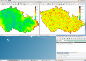
Graphical User Interface:
GRASS GIS 7.6 graphical user interface now displays the computational region extent by default in the Map Display window. This simple new feature allows to always visualize such an important basic concept in GRASS GIS and makes it a lot easier for newcomers. Moreover, a new widget has been implemented for commands including an SQL WHERE parameter to ease selection of features/data.
Show region extent in Map Display
Computational region extent
Many fixes were aimed to enhance compatibility with wxPython 4. The data catalog, the graphical modeler and the startup have also received many improvements in this new major GRASS GIS release.
Modules (commands)
A series of new modules has been added and many improved as outlined below.
General modules:
The core G7:g.region module comes with a new grow option that allows to increase or decrease by a certain number of pixels the region extent in all directions.
View history

8.2.0

Downloads:
Downloads of Grass GIS

Total downloads
21

Last month's downloads
0

Last week's downloads
0


21

Developer

Alternatives to Grass GIS

Enigeo 4.2.0 screenshot

Enigeo

... the world, while also testing your knowledge of geography. With its interactive map, you will be able ... those who want to expand their knowledge of geography. Download Enigeo today and start exploring the world! ...

Pick
Enigeo 4.2.0 DownloadEnigeo like
GeoTransformer 4.6.2.0 screenshot

GeoTransformer

... (container) hidden at that location. GeoTransformer is a powerful tool that aids in this process. This software is a boon for geocaching enthusiasts, providing a seamless way to manage GPX files. It allows users to transform their GPX files by adding ...

GeoTransformer 4.6.2.0 DownloadGeoTransformer like
GPS TrackMaker 13.9.596 screenshot

GPS TrackMaker

Top Download Club presents GPS TrackMaker - the versatile software designed and developed by Geo Studio Technology. ... user-friendly interface, you can easily create, edit, and analyze GPS tracks and waypoints. The software allows you ... outdoor adventurers alike. Get your hands on this powerful software and explore the great outdoors with confidence. ...

Pick
GPS TrackMaker 13.9.596 DownloadGPS TrackMaker like
NEWSLETTER
© 2024 TopDownload.Club  |  All rights reserved.
created by FAUST